
Make a donation
Gear up for your next adventure:
As an Amazon Associate, this site earns from qualifying purchases at no extra cost to you.
Gaillac-d'Aveyron topographic map
Click on the map to display elevation.
Make a donation
Gear up for your next adventure:
As an Amazon Associate, this site earns from qualifying purchases at no extra cost to you.
About this map
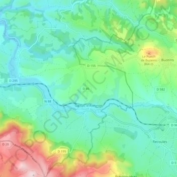
Name: Gaillac-d'Aveyron topographic map, elevation, terrain.
Average elevation: 693 m
Minimum elevation: 587 m
Maximum elevation: 992 m
Make a donation
Gear up for your next adventure:
As an Amazon Associate, this site earns from qualifying purchases at no extra cost to you.
Other topographic maps
Click on a map to view its topography, its elevation and its terrain.
Make a donation
Gear up for your next adventure:
As an Amazon Associate, this site earns from qualifying purchases at no extra cost to you.
Millau
France > Occitanie > Aveyron > Millau > Millau
Le territoire de cette commune matérialise une fraction sud du Massif central. De grande superficie (16 823 hectares, 25e commune de France métropolitaine la plus étendue), le territoire communal s'étend au cœur des Grands Causses, sur une partie du causse Rouge (à l'est du plateau du Lévézou), une…
Average elevation: 587 m
Make a donation
Gear up for your next adventure:
As an Amazon Associate, this site earns from qualifying purchases at no extra cost to you.
Château de Camboulan
France > Occitanie > Aveyron > Ambeyrac > Mas des Graves
Average elevation: 229 m
Make a donation
Gear up for your next adventure:
As an Amazon Associate, this site earns from qualifying purchases at no extra cost to you.
Conques Faubourg
France > Occitanie > Aveyron > Conques-en-Rouergue > Conques
Average elevation: 429 m