
Cantaloube topographic map
Interactive map
Click on the map to display elevation.
About this map
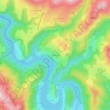
Name: Cantaloube topographic map, elevation, terrain.
Average elevation: 572 m
Minimum elevation: 410 m
Maximum elevation: 813 m
Other topographic maps
Click on a map to view its topography, its elevation and its terrain.
Prades-d'Aubrac
France > Occitanie > Aveyron > Prades-d'Aubrac
Prades-d'Aubrac, Rodez, Aveyron, Occitanie, France métropolitaine, 12470, France
Average elevation: 836 m