Geolocate

Franklin topographic map

Click on the map to display elevation.

About this map
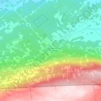
Name: Franklin topographic map, elevation, terrain.

Location: Franklin, Le Haut-Saint-Laurent, Montérégie, Quebec, Canada (44.99729 -73.99618 45.10386 -73.79552)

Average elevation: 147 m

Minimum elevation: 40 m

Maximum elevation: 345 m

Le Haut-Saint-Laurent trails, hiking, mountain biking, running and outdoor activities

Other topographic maps

Click on a map to view its topography, its elevation and its terrain.
Snye

Canada > Quebec > Le Haut-Saint-Laurent > Snye

Average elevation: 49 m

Cazaville

Canada > Quebec > Le Haut-Saint-Laurent

Average elevation: 58 m

Covey Hill

Canada > Quebec > Le Haut-Saint-Laurent > Havelock

Average elevation: 283 m

Doréa

Canada > Quebec > Le Haut-Saint-Laurent > Franklin

Average elevation: 242 m

Gear up for your next adventure:

🧦Outdoor Socks - Durable socks designed for hiking and outdoor sports
🦌Outdoor Trail Camera - Monitor wildlife activity near your favorite spots
🧥Thermal Fleece Jacket - Versatile insulation for changing mountain temperatures
⛺Camping Tent - Weather-resistant tents suitable for 2 to 6 people
🚲Bike Repair Kit - Essential tools for on-trail mechanical issues

As an Amazon Associate, this site earns from qualifying purchases at no extra cost to you.