Geolocate

Franklin topographic map

Click on the map to display elevation.

About this map

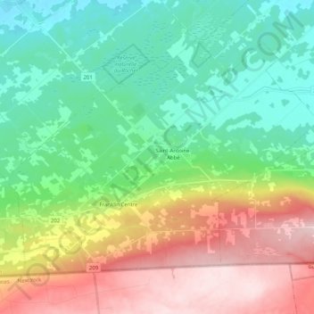
Name: Franklin topographic map, elevation, terrain.

Location: Franklin, Le Haut-Saint-Laurent, Montérégie, Quebec, Canada (44.99729 -73.99618 45.10386 -73.79552)

Average elevation: 147 m

Minimum elevation: 40 m

Maximum elevation: 345 m

Le Haut-Saint-Laurent trails, hiking, mountain biking, running and outdoor activities

Other topographic maps

Click on a map to view its topography, its elevation and its terrain.

Doréa

Canada > Quebec > Le Haut-Saint-Laurent > Franklin

Average elevation: 242 m

Covey Hill

Canada > Quebec > Le Haut-Saint-Laurent > Havelock

Average elevation: 283 m

Cazaville

Canada > Quebec > Le Haut-Saint-Laurent

Average elevation: 58 m

Snye

Canada > Quebec > Le Haut-Saint-Laurent > Snye

Average elevation: 49 m

Gear up for your next adventure:

🥘Camping Cookware Set - Compact nesting pots and pans for trail cooking
🛶Kayak Dry Bag - Waterproof storage for kayaking adventures
🔨Vehicle Emergency Tool - Safety tool for remote road trips to trailheads
🛶Waterproof Dry Bags - Keep electronics and clothes dry during river crossings
🔭Compact Monocular - One-handed bird watching and trail spotting

As an Amazon Associate, this site earns from qualifying purchases at no extra cost to you.