
Georgian Bay Islands National Park topographic map
Interactive map
Click on the map to display elevation.
About this map
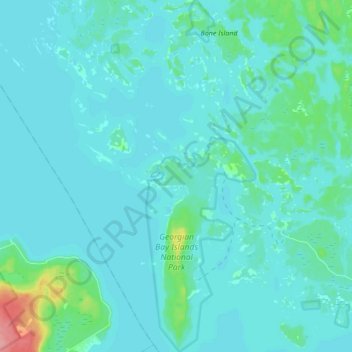
Name: Georgian Bay Islands National Park topographic map, elevation, terrain.
Average elevation: 183 m
Minimum elevation: 173 m
Maximum elevation: 263 m
Other topographic maps
Click on a map to view its topography, its elevation and its terrain.
Blue Lagoon
Canada > Ontario > Muskoka District > Georgian Bay Township
Blue Lagoon, Georgian Bay Township, District Municipality of Muskoka, Muskoka District, Central Ontario, Ontario, Canada
Average elevation: 196 m
Gray Island
Canada > Ontario > Muskoka District > Georgian Bay Township
Gray Island, Georgian Bay Township, District Municipality of Muskoka, Muskoka District, Central Ontario, Ontario, Canada
Average elevation: 196 m
Six Mile Lake
Canada > Ontario > Muskoka District > Georgian Bay Township
Six Mile Lake, Georgian Bay Township, District Municipality of Muskoka, Muskoka District, Central Ontario, Ontario, Canada
Average elevation: 193 m
Old Big Chute Marine Railway
Canada > Ontario > Muskoka District > Georgian Bay Township
Old Big Chute Marine Railway, County Road 17, Georgian Bay Township, District Municipality of Muskoka, Muskoka District, Central Ontario, Ontario, Canada
Average elevation: 198 m
MacTier
Canada > Ontario > Muskoka District > Georgian Bay Township
MacTier, Georgian Bay Township, District Municipality of Muskoka, Muskoka District, Central Ontario, Ontario, Canada
Average elevation: 241 m
Honey Harbour
Canada > Ontario > Muskoka District > Georgian Bay Township
Honey Harbour, Georgian Bay Township, District Municipality of Muskoka, Muskoka District, Central Ontario, Ontario, P0E 1E0, Canada
Average elevation: 183 m