
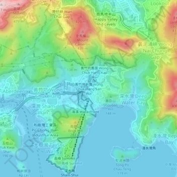
Wong Chuk Hang San Wai topographic map
Interactive map
Click on the map to display elevation.
About this map
Name: Wong Chuk Hang San Wai topographic map, elevation, terrain.
Average elevation: 116 m
Minimum elevation: -3 m
Maximum elevation: 468 m
Other topographic maps
Click on a map to view its topography, its elevation and its terrain.
Ap Lei Chau
China > Hong Kong > Hong Kong Island
Ap Lei Chau, Southern District, Hong Kong Island, Hong Kong, China
Average elevation: 25 m
Mount Davis
China > Hong Kong > Hong Kong Island
Mount Davis, Hong Kong Island, Hong Kong, China
Average elevation: 71 m
Victoria Peak
China > Hong Kong > Hong Kong Island
Victoria Peak, Hong Kong Island, Hong Kong, N/A, China
Average elevation: 209 m
Violet Hill
China > Hong Kong > Hong Kong Island
Violet Hill, Hong Kong Island, Hong Kong, China
Average elevation: 180 m
Hong Kong Island
China > Hong Kong > Hong Kong Island
Hong Kong Island, Wan Chai District, Hong Kong, China
Average elevation: 122 m