Geolocate

Karangasem topographic map

Click on the map to display elevation.

About this map
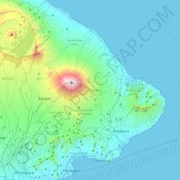
Name: Karangasem topographic map, elevation, terrain.

Location: Karangasem, Bali, Lesser Sunda Islands, Indonesia (-8.55092 115.39000 -8.16640 115.71150)

Average elevation: 381 m

Minimum elevation: 0 m

Maximum elevation: 3,007 m

Other topographic maps

Click on a map to view its topography, its elevation and its terrain.
Songan A

Indonesia > Bali > Bangli

Average elevation: 1,104 m

Bambu Indah Garden

Indonesia > Bali > Gianyar > Sayan

Average elevation: 189 m

Gear up for your next adventure:

🛶Waterproof Dry Bags - Keep electronics and clothes dry during river crossings
🌡️Emergency Mylar Blankets - Compact thermal protection for unexpected nights outdoors
🍽️Titanium Camping Spork - Ultralight and indestructible eating utensil
🧰Survival Kit - Essential gear for emergencies in the wilderness
❄️Traction Ice Cleats - Slip-on spikes for icy trails and winter hiking

As an Amazon Associate, this site earns from qualifying purchases at no extra cost to you.