Geolocate

Funbo topographic map

Click on the map to display elevation.

About this map

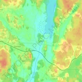
Name: Funbo topographic map, elevation, terrain.

Location: Funbo, Uppsala kommun, Uppsala County, 755 97, Sweden (59.83678 17.83658 59.87678 17.87658)

Average elevation: 19 m

Minimum elevation: 2 m

Maximum elevation: 39 m

Other topographic maps

Click on a map to view its topography, its elevation and its terrain.

Hanelundssjön

Sweden > Uppsala County > Risbergsbo

Average elevation: 68 m

Älvkarleby kommun

Sweden > Uppsala County

Average elevation: 20 m

Östhammars kommun

Sweden > Uppsala County

Average elevation: 10 m

Knivsta kommun

Sweden > Uppsala County

Average elevation: 25 m

Uppsala kommun

Sweden > Uppsala County

Average elevation: 36 m

Hargshamn

Sweden > Uppsala County

Average elevation: 5 m

Enköpings kommun

Sweden > Uppsala County

Average elevation: 24 m

Heby kommun

Sweden > Uppsala County

Average elevation: 61 m

Gear up for your next adventure:

🛏️Sleeping Bag - Warm and compact sleeping bags for outdoor camping
🧦Crew Hiking Socks - Comfortable socks for long-distance hikes
🌡️Emergency Mylar Blankets - Compact thermal protection for unexpected nights outdoors
🧦Merino Wool Socks - Moisture-wicking comfort for long-distance hiking
📷Outdoor Action Camera - Capture high-elevation views and rugged adventures

As an Amazon Associate, this site earns from qualifying purchases at no extra cost to you.