Geolocate

Quilmes topographic map

Click on the map to display elevation.

About this map

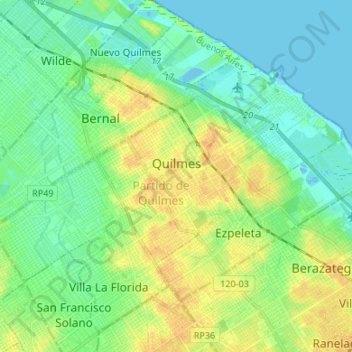
Name: Quilmes topographic map, elevation, terrain.

Location: Quilmes, Partido de Quilmes, Buenos Aires, Argentina (-34.77241 -58.33929 -34.69691 -58.20562)

Average elevation: 11 m

Minimum elevation: -5 m

Maximum elevation: 28 m

Other topographic maps

Click on a map to view its topography, its elevation and its terrain.

Emilio V. Bunge

Argentina > Buenos Aires

Average elevation: 126 m

Azul

Argentina > Buenos Aires

Average elevation: 137 m

Berisso

Argentina > Buenos Aires

Average elevation: 6 m

Grand Bourg

Argentina > Buenos Aires > Grand Bourg > Grand Bourg

Average elevation: 26 m

Gear up for your next adventure:

💡Portable Camping Lamp - Rechargeable lamp for campsite lighting
🦯Trekking Poles - Reduced impact on joints for steep topographic climbs
💡Solar Camping Lamp - Eco-friendly lighting for campsites
🥾All-Terrain Hiking Boots - Versatile boots for varied hiking conditions
🧴Outdoor Sunscreen - High SPF protection for high-altitude UV exposure

As an Amazon Associate, this site earns from qualifying purchases at no extra cost to you.