Geolocate

Palmyra topographic map

Click on the map to display elevation.

About this map
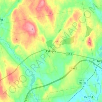
Name: Palmyra topographic map, elevation, terrain.

Location: Palmyra, Somerset County, Maine, 04965, United States (44.79720 -69.44915 44.89600 -69.28128)

Average elevation: 93 m

Minimum elevation: 50 m

Maximum elevation: 162 m

Other topographic maps

Click on a map to view its topography, its elevation and its terrain.
Pratt Hill

United States > Maine > Somerset County > Skowhegan

Average elevation: 113 m

Bigelow Hill

United States > Maine > Somerset County > Skowhegan

Average elevation: 158 m

Mackamp

United States > Maine > Somerset County

Average elevation: 395 m

Gray Island

United States > Maine > Somerset County > Solon

Average elevation: 105 m

Norris Brook

United States > Maine > Somerset County

Average elevation: 420 m

Gear up for your next adventure:

💧Hydration Pack - Hands-free hydration system for long hikes
🗺️Topographic Maps - Detailed maps to explore trails, mountains, and wilderness areas
🧴Waterproofing Spray - Restore the DWR coating on jackets and tents
🧥Softshell Hiking Jacket - The perfect balance of wind protection and breathability
🧊Insulated Water Bottle - Keeps drinks cold in summer and prevents freezing in winter

As an Amazon Associate, this site earns from qualifying purchases at no extra cost to you.