
Make a donation
Gear up for your next adventure:
As an Amazon Associate, this site earns from qualifying purchases at no extra cost to you.
Brackenfield CP topographic map
Click on the map to display elevation.
Make a donation
Gear up for your next adventure:
As an Amazon Associate, this site earns from qualifying purchases at no extra cost to you.
About this map
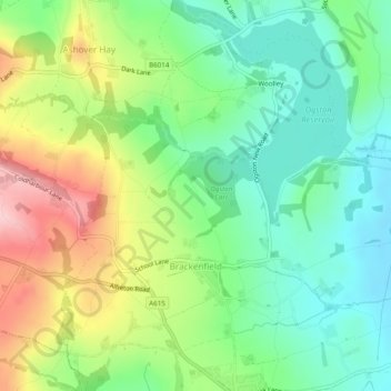
Name: Brackenfield CP topographic map, elevation, terrain.
Average elevation: 168 m
Minimum elevation: 95 m
Maximum elevation: 293 m
Make a donation
Gear up for your next adventure:
As an Amazon Associate, this site earns from qualifying purchases at no extra cost to you.
Other topographic maps
Click on a map to view its topography, its elevation and its terrain.
Lightwood
United Kingdom > England > Derbyshire > North East Derbyshire > Eckington
Average elevation: 168 m
Make a donation
Gear up for your next adventure:
As an Amazon Associate, this site earns from qualifying purchases at no extra cost to you.
Sutton Scarsdale
United Kingdom > England > Derbyshire > North East Derbyshire
Average elevation: 109 m
Ogston Reservoir
United Kingdom > England > Derbyshire > North East Derbyshire > Woolley Moor
Average elevation: 137 m
Make a donation
Gear up for your next adventure:
As an Amazon Associate, this site earns from qualifying purchases at no extra cost to you.
Doghole Wood
United Kingdom > England > Derbyshire > North East Derbyshire > Holymoorside
Average elevation: 142 m
Make a donation
Gear up for your next adventure:
As an Amazon Associate, this site earns from qualifying purchases at no extra cost to you.
Dronfield Nature Park
United Kingdom > England > Derbyshire > North East Derbyshire > Dronfield > Unstone Green
Average elevation: 156 m
Make a donation
Gear up for your next adventure:
As an Amazon Associate, this site earns from qualifying purchases at no extra cost to you.
Make a donation
Gear up for your next adventure:
As an Amazon Associate, this site earns from qualifying purchases at no extra cost to you.
Holestone Moor
United Kingdom > England > Derbyshire > North East Derbyshire > Ashover CP
Average elevation: 231 m
Norwood Cottage Lakes
United Kingdom > England > Derbyshire > North East Derbyshire > Killamarsh
Average elevation: 93 m
Highlane
United Kingdom > England > Derbyshire > North East Derbyshire > Eckington > Ridgeway
Average elevation: 130 m
Grassmoor Country Park
United Kingdom > England > Derbyshire > North East Derbyshire > Corbriggs
Average elevation: 116 m
Make a donation
Gear up for your next adventure:
As an Amazon Associate, this site earns from qualifying purchases at no extra cost to you.
Make a donation
Gear up for your next adventure:
As an Amazon Associate, this site earns from qualifying purchases at no extra cost to you.
Millthorpe
United Kingdom > England > Derbyshire > North East Derbyshire > Holmesfield > Millthorpe
Average elevation: 211 m
Troway
United Kingdom > England > Derbyshire > North East Derbyshire > Eckington > Troway
Average elevation: 157 m
Cartledge
United Kingdom > England > Derbyshire > North East Derbyshire > Holmesfield > Cartledge
Average elevation: 192 m
Make a donation
Gear up for your next adventure:
As an Amazon Associate, this site earns from qualifying purchases at no extra cost to you.