Geolocate

San Fermo topographic map

Click on the map to display elevation.

About this map

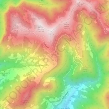
Name: San Fermo topographic map, elevation, terrain.

Location: San Fermo, Grone, Bergamo, Lombardy, 24060, Italy (45.71419 9.93443 45.75419 9.97443)

Average elevation: 915 m

Minimum elevation: 387 m

Maximum elevation: 1,318 m

Other topographic maps

Click on a map to view its topography, its elevation and its terrain.

Piazzatorre

Italy > Lombardy > Bergamo

Average elevation: 1,402 m

Albino

Italy > Lombardy > Bergamo

Average elevation: 593 m

Roncola

Italy > Lombardy > Bergamo

Average elevation: 644 m

Palosco

Italy > Lombardy > Bergamo

Average elevation: 157 m

Spinone al Lago

Italy > Lombardy > Bergamo

Average elevation: 484 m

Valcanale

Italy > Lombardy > Bergamo > Ardesio

Average elevation: 1,416 m

Serina

Italy > Lombardy > Bergamo

Average elevation: 1,107 m

Cerete

Italy > Lombardy > Bergamo

Average elevation: 812 m

Pumenengo

Italy > Lombardy > Bergamo

Average elevation: 105 m

Bagnatica

Italy > Lombardy > Bergamo

Average elevation: 223 m

Sarnico

Italy > Lombardy > Bergamo

Average elevation: 317 m

Castione della Presolana

Italy > Lombardy > Bergamo

Average elevation: 1,247 m

Castro

Italy > Lombardy > Bergamo

Average elevation: 235 m

Treviglio

Italy > Lombardy > Bergamo > Treviglio

Average elevation: 130 m

Verdello

Italy > Lombardy > Bergamo > Verdello

Average elevation: 170 m

Fara Olivana con Sola

Italy > Lombardy > Bergamo

Average elevation: 109 m

Gear up for your next adventure:

🍽️Titanium Camping Spork - Ultralight and indestructible eating utensil
🕶️Polarized Sunglasses - Protect your eyes with durable polarized lenses
🩹Compact First Aid Kit - Pre-packed essentials for common trail injuries
👟Trail Running Shoes - Agile footwear for fast-paced topographic exploration
Backpacking Tent - Lightweight tent for long-distance hiking trips

As an Amazon Associate, this site earns from qualifying purchases at no extra cost to you.