
Wapiti River topographic map
Interactive map
Click on the map to display elevation.
About this map
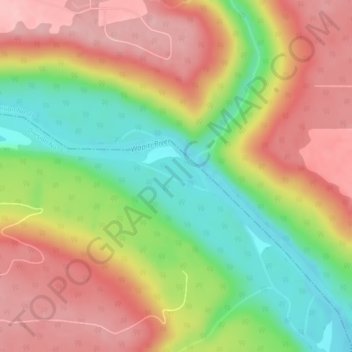
Name: Wapiti River topographic map, elevation, terrain.
Location: Wapiti River, Grande Prairie, Alberta, Canada (55.07536 -118.94797 55.07754 -118.93856)
Average elevation: 606 m
Minimum elevation: 522 m
Maximum elevation: 678 m
Alberta trails, hiking, mountain biking, running and outdoor activities
Other topographic maps
Click on a map to view its topography, its elevation and its terrain.
Grande Prairie
Canada > Alberta > Grande Prairie
Grande Prairie is located just north of the 55th parallel north, and is 465 km (289 mi) northwest of Edmonton, lying at an elevation of 669 m (2,195 ft) above sea level. The city is surrounded by farmland to the north, east, and west. To the south lies a vast boreal forest with aspen, tamarack, lodgepole pine,…
Average elevation: 668 m