
Make a donation
Gear up for your next adventure:
As an Amazon Associate, this site earns from qualifying purchases at no extra cost to you.
Becerreá topographic map
Click on the map to display elevation.
Make a donation
Gear up for your next adventure:
As an Amazon Associate, this site earns from qualifying purchases at no extra cost to you.
Becerreá
Mit der benachbarten Gemeinde von As Nogais, teilt die Gemeinde die besondere Erhaltungszone (ZEC) Cruzul-Agrerch, einen natürlichen Raums des Natura 2000-Netzwerks der Europäischen Union. Das Gebiet wird von zwei einzigartigen Wäldern besetzt, die ein seltenes Beispiel für Koexistenz zwischen mediterranen Arten und autochthonen Arten dieser Atlantikzone zeigen: die Steineiche de Cruzul, die nördlichste Eiche der Halbinsel und der Kastanienwald (Soto) von Agüeira, der sich mit Eichen auf den obersten Berghöhen vermischt.
Make a donation
Gear up for your next adventure:
As an Amazon Associate, this site earns from qualifying purchases at no extra cost to you.
About this map
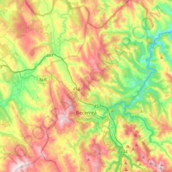
Name: Becerreá topographic map, elevation, terrain.
Location: Becerreá, Os Ancares, Lugo, Galicien, Spanien (42.78785 -7.23071 42.98039 -7.05543)
Average elevation: 705 m
Minimum elevation: 322 m
Maximum elevation: 1,197 m
Make a donation
Gear up for your next adventure:
As an Amazon Associate, this site earns from qualifying purchases at no extra cost to you.
Other topographic maps
Click on a map to view its topography, its elevation and its terrain.