
Tianjin topographic map
Interactive map
Click on the map to display elevation.
About this map
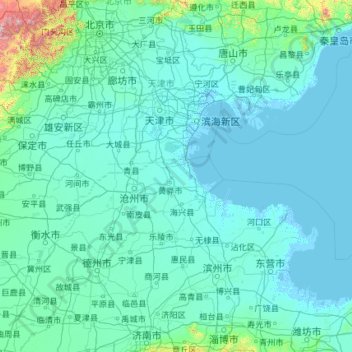
Name: Tianjin topographic map, elevation, terrain.
Location: Tianjin, China (36.56626 113.72998 40.25201 118.05867)
Average elevation: 64 m
Minimum elevation: -4 m
Maximum elevation: 2,561 m
Laut einer Studie aus dem Jahr 2014 erwirtschafte Tianjin ein Bruttoinlandsprodukt von 371,9 Milliarden US-Dollar (KKB). In der Rangliste der wirtschaftsstärksten Metropolregionen weltweit belegte sie damit den 20. Platz und den vierten Platz in China. Das BIP pro Kopf lag bei 24.224 US-Dollar womit Tianjin unter die wohlhabendsten Regionen der Volksrepublik einzuordnen ist. Von 2000 bis 2014 wuchs das BIP pro Kopf im Durchschnitt jedes Jahr zweistellig und 2014 noch mit 3,3 Prozent. 2014 gab es in der Stadt 5,7 Millionen Arbeitsplätze. Die Industrie beschäftigt 2006 etwa 41 Prozent der Arbeitskräfte Tianjins und erwirtschaftet die Hälfte des BIP. Die Industrieproduktion lag im Jahre 2000 etwas höher als jene von Guangzhou oder Shenzhen. Etwa zwei Drittel werden von der Schwerindustrie umgesetzt, wobei große Unternehmen dominieren, die Tendenz jedoch fallend ist.
Other topographic maps
Click on a map to view its topography, its elevation and its terrain.
四姑娘山海子沟景区
China > Sichuan > 小金县 བཙན་ལྷ་རྫོང་།
四姑娘山海子沟景区, 小金县 བཙན་ལྷ་རྫོང་།, 阿坝藏族羌族自治州 རྔ་བ་བོད་རིགས་ཆ་བ༹ང་རིགས་རང་སྐྱོང་ཁུལ་, Sichuan, 624200, China
Average elevation: 4,270 m
班戈县 དཔལ་མགོན་རྫོང།
班戈县 དཔལ་མགོན་རྫོང།, Nagqu, Tibet, 852500, China
Average elevation: 4,877 m
帕里镇 ཕག་ར
China > Tibet > 亚东县 གྲོ་མོ་རྫོང།
帕里镇 ཕག་ར, 亚东县 གྲོ་མོ་རྫོང།, Shigatse, Tibet, China
Average elevation: 4,478 m
巴日嘎斯台乡
巴日嘎斯台乡, 科尔沁右翼前旗 ᠬᠣᠷᠴᠢᠨ ᠪᠠᠷᠠᠭᠤᠨ ᠭᠠᠷᠤᠨ ᠡᠮᠦᠨᠡᠳᠦ ᠬᠣᠰᠢᠭᠤ, Hinggan, Innere Mongolei, China
Average elevation: 451 m
锡林郭勒盟 ᠰᠢᠯᠢ ᠶᠢᠨ ᠭᠣᠣᠯ ᠠᠶᠢᠮᠠᠭ
锡林郭勒盟 ᠰᠢᠯᠢ ᠶᠢᠨ ᠭᠣᠣᠯ ᠠᠶᠢᠮᠠᠭ, Innere Mongolei, 692485, China
Average elevation: 1,058 m
Macao
China > Macau > 風順堂區 São Lourenço
Macao, 風順堂區 São Lourenço, Concelho de Macau, Macau, 519020, China
Average elevation: 17 m
扯旗山 Victoria Peak
China > Hongkong > Hong Kong Island
扯旗山 Victoria Peak, Hong Kong Island, Hongkong, China
Average elevation: 209 m
Victoria Peak Lookout (over the Victoria Harbour)
China > Hongkong > Hong Kong Island
Victoria Peak Lookout (over the Victoria Harbour), 盧吉道 Lugard Road, 太平山 Victoria Peak, 山頂 The Peak, 中西區 Central and Western District, Hong Kong Island, Hongkong, China
Average elevation: 191 m