
Maranhão topographic map
Interactive map
Click on the map to display elevation.
About this map
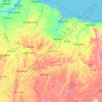
Name: Maranhão topographic map, elevation, terrain.
Location: Maranhão, Northeast Region, Brazil (-10.26194 -48.75584 -0.75938 -41.68920)
Average elevation: 210 m
Minimum elevation: -3 m
Maximum elevation: 1,201 m
Other topographic maps
Click on a map to view its topography, its elevation and its terrain.
Sugarloaf
Brazil > Rio de Janeiro > Região Metropolitana do Rio de Janeiro > Rio de Janeiro
Average elevation: 17 m
Umuarama
Brazil > Paraná > Região Metropolitana de Umuarama
Umuarama is a municipality in the state of Paraná in Brazil. Its population was 112,500 inhabitants in 2020. Umuarama is one of the most important cities in Paraná, one of the three states of southern Brazil. The city elevation is 430 m (1,300 feet) above sea level and the rainfall is about 1600mm/year (63…
Average elevation: 377 m
Várzea Paulista
Várzea Paulista is a municipality in the state of São Paulo in Brazil. The population is 123,071 (2020 est.) in an area of 35.1 km2. The elevation is 745 m. It is part of the agglomeration of Jundiaí.
Average elevation: 785 m
Brasília
Brazil > Federal District > Região Integrada de Desenvolvimento do Distrito Federal e Entorno
The city sits at an elevation of 1,000 metres (3,300 ft) and more, high on the Brazilian Highlands in the country's center-western region. Paranoá Lake, a large artificial lake, was built to increase the amount of water available and to maintain the region's humidity. It has a marina, and hosts wakeboarders…
Average elevation: 1,084 m
Cuiabá
The Massairo Okamura State Park provides a green space with typical cerrado vegetation in the centre of a highly urbanized area. It helps preserve the headwaters of the Barbado and Moinho streams. The 66 hectares (160 acres) Zé Bolo Flô State Park is in the Grande Coxipó district. The city also includes the…
Average elevation: 259 m
São José dos Campos
Brazil > São Paulo > Região Metropolitana do Vale do Paraíba e Litoral Norte
Highlands predominate in the northern region of the municipality with altitudes ranging from 660 to 975 m (2,165 to 3,199 ft). The northern border of the municipality lies over the Serra da Mantiqueira Mountains (Mantiqueira Range), with some peaks reaching over 2000 meters (6500 ft.). The highest point in the…
Average elevation: 824 m
Porto Alegre
Brazil > Rio Grande do Sul > Metropolitan Region of Porto Alegre
Porto Alegre has a long coastline on the Guaíba Lake, and its topography is punctuated by 40 hills. In the lake, a vast body of water, a maze of islands facing the city creates an archipelago where a unique ecosystem gives shelter to abundant wildlife. The city area concentrates 28% of the native flora of Rio…
Average elevation: 26 m
Belo Horizonte
Brazil > Minas Gerais > Região Metropolitana de Belo Horizonte
In 1893, due to the climatic and topographic conditions, Curral Del Rey was selected by Minas Gerais governor Afonso Pena among other cities as the location for the new economic and cultural center of the state, under the new name of Cidade de Minas, or City of Minas.
Average elevation: 895 m
Santa Catarina
It is one of the Brazilian states with the most mountainous terrain, where 52% of the territory is located above 600 metres. According to the Köppen-Geiger climate classification system, Santa Catarina predominantly features a humid subtropical climate (Cfa) in the coastal lowlands and the lower altitude…
Average elevation: 530 m
Pelotas
Brazil > Rio Grande do Sul > Aglomeração Urbana do Sul
As it is situated on a plain near the ocean, the urban area lies on a low elevation, being, on average, 7 meters (23 ft) above sea level. The interior of the municipality is on a plateau called Serras de Sudeste (Southeastern Mountain Ranges). Consequently, the altitude in Pelotas' rural area reaches 429…
Average elevation: 85 m
Espírito Santo
The Captaincy of Espírito Santo was carved out of the Captaincy of Bahia in the 18th century, during the colonial rule of Brazil, and named after a 16th-century captaincy covering roughly the same area of coast. Following the elevation of Brazil to a constituent kingdom of United Kingdom of Portugal, Brazil…
Average elevation: 265 m
Roraima
Mount Roraima, located in Pacaraima Mountains, is the highest point in the state and one of the highest in the country, with 2,875 m (9,400 feet). The relief in the state is quite varied. Near the borders of Venezuela and Guyana are the mountains of Parima and Pacaraima, where Mount Roraima is located, with an…
Average elevation: 260 m
Paraíba do Sul
Located at 306 m altitude, Paraíba do Sul is located at latitude 22°09'43" south and longitude 43°17'34" west. It has an area of 582.21 square kilometres (224.79 sq mi).
Average elevation: 512 m
Santos
Brazil > São Paulo > Região Metropolitana da Baixada Santista
Santos partially lies on the island of São Vicente (Saint Vincent), whose territory is divided with the neighboring municipality of São Vicente. It is a densely urbanized area of 39.4 km2 (15.2 sq mi) that houses almost all the inhabitants of the city. It includes a flat area - Plain Coastal extension of the…
Average elevation: 331 m
Ceará
Ceará lies partly upon the northeast slope of the Brazilian Highlands, and partly upon the sandy coastal plain. Its surface is a succession of great terraces, facing north and northeast, formed by the denudation of the ancient sandstone plateau which once covered this part of the continent; the terraces are…
Average elevation: 257 m
Palmas
Palmas is located at the state's geographic centre at an average altitude of 230 m (755 ft). The city is located between the Serra do Lajeado hills on the east and the Tocantins River on the west. Palmas has a metropolitan area with 471,639 inhabitants.
Average elevation: 367 m
Federal District
From the first republican constitution there was already a device that foresaw the move of the federal capital from Rio de Janeiro, at that time in the former Federal District (1889-1960), to the interior of the country. In 1891 the Exploration Commission of the Central Highlands of Brazil was appointed, led…
Average elevation: 983 m
São João da Boa Vista
São João da Boa Vista (Portuguese pronunciation: [ˈsɐ̃w ʒuˈɐ̃w dɐ ˈboɐ ˈvistɐ]; "Saint John of the Good View" in English) is a municipality in the state of São Paulo, Brazil. The population in 2020 was 91,771 and the area is 516.399 square kilometres (199.383 sq mi). The elevation is 767 metres (2,516 ft).
Average elevation: 866 m