Geolocate

Maceió topographic map

Click on the map to display elevation.

About this map
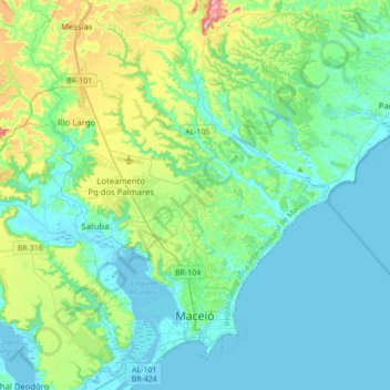
Name: Maceió topographic map, elevation, terrain.

Location: Maceió, Região Geográfica Imediata de Maceió, Região Geográfica Intermediária de Maceió, Alagoas, Northeast Region, Brazil (-9.71314 -35.81435 -9.37100 -35.55833)

Average elevation: 54 m

Minimum elevation: -3 m

Maximum elevation: 280 m

Other topographic maps

Click on a map to view its topography, its elevation and its terrain.
Barra Nova

Brazil > Alagoas > Marechal Deodoro

Average elevation: 10 m

Gear up for your next adventure:

🧭GPS Tracker - Track your location in remote areas safely
📷Outdoor Action Camera - Capture high-elevation views and rugged adventures
💡Solar Camping Lamp - Eco-friendly lighting for campsites
👟Trail Running Shoes - Agile footwear for fast-paced topographic exploration
💡Compact LED Flashlight - Powerful and portable flashlight for outdoor use

As an Amazon Associate, this site earns from qualifying purchases at no extra cost to you.