Geolocate

Sugarloaf topographic map

Click on the map to display elevation.

About this map

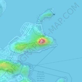
Name: Sugarloaf topographic map, elevation, terrain.

Location: Sugarloaf, Rio de Janeiro, Southeast Region, 22291-090, Brazil (-22.94954 -43.15621 -22.94944 -43.15611)

Average elevation: 17 m

Minimum elevation: -5 m

Maximum elevation: 372 m

Other topographic maps

Click on a map to view its topography, its elevation and its terrain.

Rocinha

Brazil > Rio de Janeiro > Rio de Janeiro

Average elevation: 161 m

Santa Teresa

Brazil > Rio de Janeiro > Rio de Janeiro

Around 1850 many people, fleeing the yellow fever epidemic in the city, flocked to the neighborhood. As it was at a higher altitude, Santa Teresa was less affected by the epidemic than the surrounding neighborhoods.

Average elevation: 55 m

São Conrado

Brazil > Rio de Janeiro > Rio de Janeiro

Average elevation: 115 m

Laranjeiras

Brazil > Rio de Janeiro > Rio de Janeiro

Average elevation: 68 m

Gear up for your next adventure:

🥤Collapsible Travel Cup - Saves space and weight in your mess kit
🥾Durable Hiking Shoes - Long-lasting shoes for frequent hiking
🧭GPS Tracker - Track your location in remote areas safely
🧢Outdoor Cap - Protective cap for sun and rain during hikes
🕶️Polarized Sunglasses - Reduces glare from snow and water at high elevations

As an Amazon Associate, this site earns from qualifying purchases at no extra cost to you.