
Make a donation
Gear up for your next adventure:
As an Amazon Associate, this site earns from qualifying purchases at no extra cost to you.
Pittsburg County topographic map
Click on the map to display elevation.
Make a donation
Gear up for your next adventure:
As an Amazon Associate, this site earns from qualifying purchases at no extra cost to you.
Pittsburg County
According to the U.S. Census Bureau, the county has a total area of 1,378 square miles (3,570 km2), of which 1,305 square miles (3,380 km2) is land and 72 square miles (190 km2) (5.3%) is water. The county's topography is generally hilly to mountainous. The Ouachita Mountains extend into the southeastern portion. The Canadian River drains most of the county and with Eufaula Lake form the northern boundary of the county. The southern part of the county is drained by several creeks that flow into the Kiamichi River and then into the Red River.
Make a donation
Gear up for your next adventure:
As an Amazon Associate, this site earns from qualifying purchases at no extra cost to you.
About this map
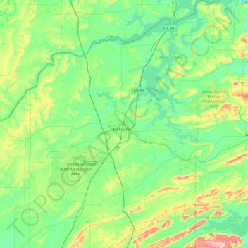
Name: Pittsburg County topographic map, elevation, terrain.
Location: Pittsburg County, Oklahoma, United States (34.59353 -96.09220 35.30063 -95.34878)
Average elevation: 234 m
Minimum elevation: 147 m
Maximum elevation: 564 m
Make a donation
Gear up for your next adventure:
As an Amazon Associate, this site earns from qualifying purchases at no extra cost to you.
Other topographic maps
Click on a map to view its topography, its elevation and its terrain.
Southwest Oklahoma City Sludge Lagoon Dam
United States > Oklahoma > Cleveland County > Oklahoma City
Average elevation: 348 m
Make a donation
Gear up for your next adventure:
As an Amazon Associate, this site earns from qualifying purchases at no extra cost to you.
Lake Thunderbird Dam
United States > Oklahoma > Cleveland County > Norman > Little Axe
Average elevation: 318 m