Beaver County topographic map
Click on the map to display elevation.
About this map
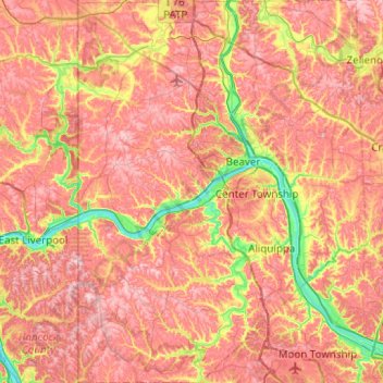
Name: Beaver County topographic map, elevation, terrain.
Location: Beaver County, Pennsylvania, United States (40.47717 -80.51934 40.85414 -80.14483)
Average elevation: 325 m
Minimum elevation: 201 m
Maximum elevation: 414 m
Other topographic maps
Click on a map to view its topography, its elevation and its terrain.
Albrightsville
United States > Pennsylvania > Carbon County > Kidder Township
Average elevation: 498 m

East Texas
United States > Pennsylvania > Lehigh County > Lower Macungie Township
Average elevation: 126 m
West Pittsburg
United States > Pennsylvania > Lawrence County > Taylor Township
Average elevation: 279 m
Acme
United States > Pennsylvania > Westmoreland County > Mount Pleasant Township
Average elevation: 585 m

Elkins Park Gardens
United States > Pennsylvania > Montgomery County > Cheltenham Township > Cheltenham
Average elevation: 70 m
Strawberry Mansion
United States > Pennsylvania > Philadelphia County > Philadelphia
Average elevation: 31 m

West Derry
United States > Pennsylvania > Westmoreland County > Derry Township
Average elevation: 408 m

Wilson Mills
United States > Pennsylvania > Venango County > Jackson Township
Average elevation: 453 m

Hooverville
United States > Pennsylvania > Westmoreland County > Saint Clair Township
Average elevation: 385 m
English Center
United States > Pennsylvania > Lycoming County > Pine Township
Average elevation: 444 m
Reservoir Heights
United States > Pennsylvania > Dauphin County > Upper Paxton Township
Average elevation: 189 m

Woxall
United States > Pennsylvania > Montgomery County > Upper Salford Township
Average elevation: 98 m
Long Pond
United States > Pennsylvania > Monroe County > Tunkhannock Township
Long Pond is named after the unique wetland topography formed by the Tunkhannock Creek. Within the Long Pond community, public access lands are owned and protected by The Bethlehem Authority, Nature Conservancy, Wildlands Conservancy County of Monroe Open Space Program, , PA Game Commission and PA Department…
Average elevation: 571 m
Penn Valley
United States > Pennsylvania > Montgomery County > Lower Merion Township > Ardmore
Average elevation: 89 m


Garrett Hill
United States > Pennsylvania > Delaware County > Radnor Township > Radnor
Average elevation: 117 m


Carlisle Springs
United States > Pennsylvania > Cumberland County > Middlesex Township
Average elevation: 182 m


Brittains Corner
United States > Pennsylvania > Chester County > Schuylkill Township > Valley Forge
Average elevation: 81 m


East Kensington
United States > Pennsylvania > Westmoreland County > New Kensington
Average elevation: 275 m
Dingmans Ferry
United States > Pennsylvania > Pike County > Delaware Township
Average elevation: 192 m

White Church
United States > Pennsylvania > Westmoreland County > North Huntingdon Township
Average elevation: 331 m

Mount Nebo Park
United States > Pennsylvania > Monroe County > East Stroudsburg > Twin Falls
Average elevation: 185 m

Pricetown
United States > Pennsylvania > Berks County > Ruscombmanor Township
Average elevation: 239 m
Cornwells Heights
United States > Pennsylvania > Bucks County > Bensalem Township
Average elevation: 16 m
Cowden
United States > Pennsylvania > Washington County > Cecil Township > Cecil
Average elevation: 346 m
Keown Station
United States > Pennsylvania > Allegheny County > Ross Township
Average elevation: 344 m

Stony Creek Mills
United States > Pennsylvania > Berks County > Lower Alsace Township > Pennside
Average elevation: 192 m

Riddlesburg
United States > Pennsylvania > Bedford County > Broad Top Township
Average elevation: 373 m
New Enterprise
United States > Pennsylvania > Bedford County > South Woodbury Township
Average elevation: 397 m
Blue Knob
United States > Pennsylvania > Bedford County > Pavia Township
Blue Knob (elevation 3,146 feet (959 m)) is a summit in the eastern United States with a broad dome that is the northernmost 3,000-footer in the Allegheny Mountains. It is the highest point in Bedford County, Pennsylvania.
Average elevation: 792 m

Sinnemahoning
United States > Pennsylvania > Cameron County > Gibson Township
Average elevation: 406 m
Saint Benedict
United States > Pennsylvania > Cambria County > West Carroll Township
Average elevation: 582 m

Tyrrel Farm Corners
United States > Pennsylvania > Venango County > Allegheny Township
Average elevation: 478 m
Rockville
United States > Pennsylvania > Dauphin County > Susquehanna Township
Average elevation: 141 m
Fort Hunter
United States > Pennsylvania > Dauphin County > Middle Paxton Township
Average elevation: 149 m

Green Village
United States > Pennsylvania > Franklin County > Greene Township
Average elevation: 207 m
Normalville
United States > Pennsylvania > Fayette County > Springfield Township
Average elevation: 486 m
Arnold City
United States > Pennsylvania > Fayette County > Washington Township
Average elevation: 303 m
Three Tuns
United States > Pennsylvania > Montgomery County > Upper Dublin Township > Maple Glen
Average elevation: 101 m
Hidden Valley
United States > Pennsylvania > Montgomery County > Upper Merion Township
Average elevation: 47 m
Worcester
United States > Pennsylvania > Montgomery County > Worcester Township
Average elevation: 93 m
Strafford
United States > Pennsylvania > Chester County > Tredyffrin Township
Average elevation: 133 m
Pennsylvania Furnace
United States > Pennsylvania > Huntingdon County > Franklin Township
Average elevation: 363 m
Dilltown
United States > Pennsylvania > Indiana County > East Wheatfield Township
Average elevation: 474 m
Robinson
United States > Pennsylvania > Indiana County > West Wheatfield Township
Average elevation: 397 m
Hazelton Mills
United States > Pennsylvania > McKean County > Bradford Township
Average elevation: 598 m
Fogelsville
United States > Pennsylvania > Lehigh County > Upper Macungie Township
Average elevation: 155 m