
Make a donation
Gear up for your next adventure:
As an Amazon Associate, this site earns from qualifying purchases at no extra cost to you.
Manzoro topographic map
Click on the map to display elevation.
Make a donation
Gear up for your next adventure:
As an Amazon Associate, this site earns from qualifying purchases at no extra cost to you.
About this map
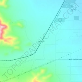
Name: Manzoro topographic map, elevation, terrain.
Location: Manzoro, Cochise County, Arizona, United States (32.02480 -109.99090 32.06480 -109.95090)
Average elevation: 1,370 m
Minimum elevation: 1,322 m
Maximum elevation: 1,586 m
Make a donation
Gear up for your next adventure:
As an Amazon Associate, this site earns from qualifying purchases at no extra cost to you.
Other topographic maps
Click on a map to view its topography, its elevation and its terrain.
Make a donation
Gear up for your next adventure:
As an Amazon Associate, this site earns from qualifying purchases at no extra cost to you.
Kartchner Caverns State Park
United States > Arizona > Cochise County > Benson
Average elevation: 1,432 m