
Old City topographic map
Interactive map
Click on the map to display elevation.
About this map
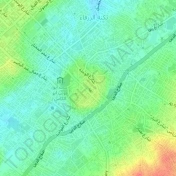
Name: Old City topographic map, elevation, terrain.
Location: Old City, محافظة غزة, Gazastrook, Palestinian Territory (31.49993 34.45862 31.50899 34.47102)
Average elevation: 39 m
Minimum elevation: 22 m
Maximum elevation: 74 m
Other topographic maps
Click on a map to view its topography, its elevation and its terrain.
שטח C
Palestinian Territory > Judea en Samaria (district)
שטח C, Judea en Samaria (district), 113, Palestinian Territory
Average elevation: 339 m
Dode Zee
Palestinian Territory > Judea en Samaria (district) > שטח C
Dode Zee, שטח C, Judea en Samaria (district), Palestinian Territory
Average elevation: 105 m
Palestijnse Gebieden
Palestijnse Gebieden, Palestinian Territory
Average elevation: 44 m
Jericho
Palestinian Territory > منطقة أ
Jericho, منطقة أ, Westelijke Jordaanoever, Palestinian Territory
Average elevation: -244 m
יהודה ושומרון
Palestinian Territory > יהודה ושומרון
יהודה ושומרון, Palestinian Territory
Average elevation: 287 m
رام الله
Palestinian Territory > منطقة أ > رام الله
رام الله, منطقة أ, יהודה ושומרון, Palestinian Territory
Average elevation: 795 m