
שטח C topographic map
Interactive map
Click on the map to display elevation.
About this map
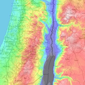
Name: שטח C topographic map, elevation, terrain.
Location: שטח C, Judea en Samaria (district), 113, Palestinian Territory (31.34211 34.88006 32.55215 35.57392)
Average elevation: 339 m
Minimum elevation: -415 m
Maximum elevation: 1,236 m
Other topographic maps
Click on a map to view its topography, its elevation and its terrain.
Dode Zee
Palestinian Territory > Judea en Samaria (district) > שטח C
Dode Zee, שטח C, Judea en Samaria (district), Palestinian Territory
Average elevation: 105 m