
Make a donation
Gear up for your next adventure:
As an Amazon Associate, this site earns from qualifying purchases at no extra cost to you.
Brownsburg-Chatham topographic map
Click on the map to display elevation.
Make a donation
Gear up for your next adventure:
As an Amazon Associate, this site earns from qualifying purchases at no extra cost to you.
About this map
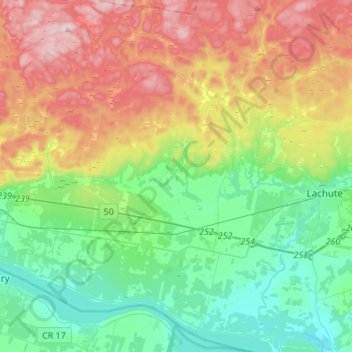
Name: Brownsburg-Chatham topographic map, elevation, terrain.
Location: Brownsburg-Chatham, Argenteuil, Laurentides, Quebec, Canada (45.57000 -74.55642 45.75998 -74.32769)
Average elevation: 147 m
Minimum elevation: 24 m
Maximum elevation: 371 m
Argenteuil trails, hiking, mountain biking, running and outdoor activities
Make a donation
Gear up for your next adventure:
As an Amazon Associate, this site earns from qualifying purchases at no extra cost to you.
Other topographic maps
Click on a map to view its topography, its elevation and its terrain.
Make a donation
Gear up for your next adventure:
As an Amazon Associate, this site earns from qualifying purchases at no extra cost to you.
Pointe-au-Chêne
Canada > Quebec > Argenteuil > Grenville-sur-la-Rouge > Pointe-au-Chêne
Average elevation: 94 m
Make a donation
Gear up for your next adventure:
As an Amazon Associate, this site earns from qualifying purchases at no extra cost to you.
Make a donation
Gear up for your next adventure:
As an Amazon Associate, this site earns from qualifying purchases at no extra cost to you.