
Make a donation
Gear up for your next adventure:
As an Amazon Associate, this site earns from qualifying purchases at no extra cost to you.
Río Cuarto topographic map
Click on the map to display elevation.
Make a donation
Gear up for your next adventure:
As an Amazon Associate, this site earns from qualifying purchases at no extra cost to you.
Río Cuarto
Río Cuarto has an area of 254.2 km2 (98.1 sq mi) and a mean elevation of 277 metres.
Make a donation
Gear up for your next adventure:
As an Amazon Associate, this site earns from qualifying purchases at no extra cost to you.
About this map
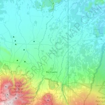
Name: Río Cuarto topographic map, elevation, terrain.
Location: Río Cuarto, Alajuela Province, Costa Rica (10.24190 -84.26577 10.57731 -84.16116)
Average elevation: 429 m
Minimum elevation: 21 m
Maximum elevation: 2,285 m
Make a donation
Gear up for your next adventure:
As an Amazon Associate, this site earns from qualifying purchases at no extra cost to you.
Other topographic maps
Click on a map to view its topography, its elevation and its terrain.
Arenal Volcano
Costa Rica > Alajuela Province > Cantón de San Carlos > La Fortuna
Arenal has several eruptive vents. Chato is a dormant stratovolcanic cone. It is believed that Chato first erupted 38,000 years ago during the Pleistocene period and last erupted about 3,500 years ago. Chatito is a lava dome with an elevation of 1,100 metres (3,609 ft). Espina is another lava dome.
Average elevation: 1,014 m
Make a donation
Gear up for your next adventure:
As an Amazon Associate, this site earns from qualifying purchases at no extra cost to you.
Grande River
Costa Rica > Alajuela Province > San Ramón > San Isidro > San Roque
Average elevation: 1,045 m
Make a donation
Gear up for your next adventure:
As an Amazon Associate, this site earns from qualifying purchases at no extra cost to you.
La Paz
Costa Rica > Alajuela Province > Cantón de San Ramón > Piedades Norte
Average elevation: 1,166 m
Make a donation
Gear up for your next adventure:
As an Amazon Associate, this site earns from qualifying purchases at no extra cost to you.
Make a donation
Gear up for your next adventure:
As an Amazon Associate, this site earns from qualifying purchases at no extra cost to you.
Carrillos Alto
Costa Rica > Alajuela Province > Poás > Carrillos > Carrillos Bajo
Average elevation: 911 m
Arenal Volcano
Costa Rica > Alajuela Province > San Carlos > La Fortuna
Arenal has several eruptive vents. Chato is a dormant stratovolcanic cone. It is believed that Chato first erupted 38,000 years ago during the Pleistocene period and last erupted about 3,500 years ago. Chatito is a lava dome with an elevation of 1,100 metres (3,609 ft). Espina is another lava dome.
Average elevation: 1,014 m
Carrillos Bajo
Costa Rica > Alajuela Province > Cantón Poás > Carrillos > Carrillos Bajo
Average elevation: 834 m
Make a donation
Gear up for your next adventure:
As an Amazon Associate, this site earns from qualifying purchases at no extra cost to you.