Geolocate

Taconite topographic map

Click on the map to display elevation.

About this map

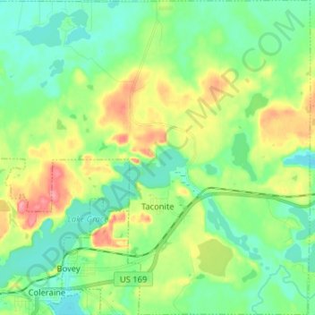
Name: Taconite topographic map, elevation, terrain.

Location: Taconite, Itasca County, Minnesota, United States (47.28241 -93.44804 47.37014 -93.31941)

Average elevation: 420 m

Minimum elevation: 390 m

Maximum elevation: 481 m

Other topographic maps

Click on a map to view its topography, its elevation and its terrain.

Togo

United States > Minnesota > Itasca County

Average elevation: 408 m

Upper Twin Lakes

United States > Minnesota > Itasca County > Rosy

Average elevation: 409 m

Candy Lake

United States > Minnesota > Itasca County

Average elevation: 421 m

Gear up for your next adventure:

🎒Hiking Backpack - Lightweight and ergonomic backpacks for day hikes or multi-day treks
🥾Approach Boots - Comfortable boots for hiking and climbing approaches
🛶Kayak Dry Bag - Waterproof storage for kayaking adventures
🚲Heavy Duty Bike Lock - Secure your bike at the trailhead or during stops
🦌Outdoor Trail Camera - Monitor wildlife activity near your favorite spots

As an Amazon Associate, this site earns from qualifying purchases at no extra cost to you.