Geolocate

Petersberg topographic map

Click on the map to display elevation.

About this map
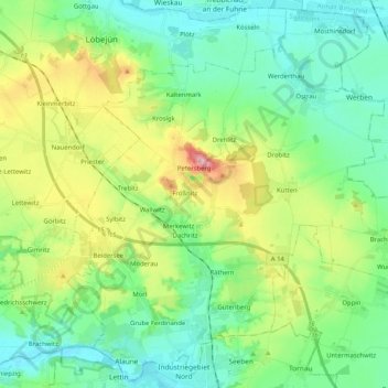
Name: Petersberg topographic map, elevation, terrain.

Location: Petersberg, Saalekreis, Saxony-Anhalt, Germany (51.52428 11.88254 51.64656 12.08764)

Average elevation: 122 m

Minimum elevation: 71 m

Maximum elevation: 244 m

Other topographic maps

Click on a map to view its topography, its elevation and its terrain.

Wassertal

Germany > Saxony-Anhalt > Saalekreis > Schkopau > Knapendorf

Average elevation: 101 m

Luppenau

Germany > Saxony-Anhalt > Saalekreis > Schkopau

Average elevation: 86 m

Drehlitz

Germany > Saxony-Anhalt > Saalekreis

Average elevation: 140 m

Rumpin

Germany > Saxony-Anhalt > Saalekreis > Salzatal

Average elevation: 106 m

Gear up for your next adventure:

👖Convertible Hiking Pants - Zip-off legs to adapt to changing weather conditions
🌡️Emergency Mylar Blankets - Compact thermal protection for unexpected nights outdoors
🔥Emergency Fire Starter - Reliable ignition source for all weather conditions
🧢Outdoor Visor - Breathable visor for sunny hikes
🧭GPS Outdoor Watch - Smart watch for navigation and fitness tracking in nature

As an Amazon Associate, this site earns from qualifying purchases at no extra cost to you.