Geolocate

Fort Davis topographic map

Click on the map to display elevation.

About this map

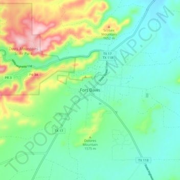
Name: Fort Davis topographic map, elevation, terrain.

Location: Fort Davis, Jeff Davis County, Texas, United States (30.54916 -103.93496 30.62916 -103.85496)

Average elevation: 1,526 m

Minimum elevation: 1,445 m

Maximum elevation: 1,735 m

Other topographic maps

Click on a map to view its topography, its elevation and its terrain.

Valentine

United States > Texas > Jeff Davis County

Average elevation: 1,352 m

Gear up for your next adventure:

🔪Outdoor Multitool - Versatile tool for repairs and food prep in the wild
🛶Kayak Dry Bag - Waterproof storage for kayaking adventures
💧Collapsible Water Bottle - Space-saving water bottle for outdoor activities
🧭GPS Tracker - Track your location in remote areas safely
🦟Insect Repellent - Keep mosquitoes and black flies away in wooded areas

As an Amazon Associate, this site earns from qualifying purchases at no extra cost to you.