
Nuneaton topographic map
Click on the map to display elevation.
About this map
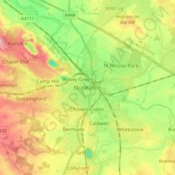
Name: Nuneaton topographic map, elevation, terrain.
Average elevation: 102 m
Minimum elevation: 39 m
Maximum elevation: 171 m
Other topographic maps
Click on a map to view its topography, its elevation and its terrain.
Nuneaton Common
United Kingdom > England > Warwickshire > Nuneaton and Bedworth
Average elevation: 127 m
Vale View
United Kingdom > England > Warwickshire > Nuneaton and Bedworth > Nuneaton
Average elevation: 113 m