
Sauerlach topographic map
Click on the map to display elevation.
Sauerlach
Das Gelände der Gemeinde steigt von Nordosten nach Südwesten zunächst gering, dann stärker an. Der Höhenunterschied im Gemeindegebiet beträgt etwa 100 Meter. Im Buchetholz, am südwestlichen Rand der Gemeinde, südlich von Gumpertsham, befindet sich mit knapp 700 Metern die höchste Erhebung. Der tiefste Punkt liegt an der nördlichen Gemeindegrenze bei Otterloh bei rund 600 Metern.
About this map
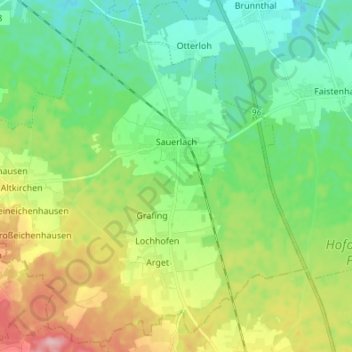
Name: Sauerlach topographic map, elevation, terrain.
Location: Sauerlach, Landkreis München, Bayern, 82054, Deutschland (47.91997 11.56644 48.00622 11.70239)
Average elevation: 635 m
Minimum elevation: 583 m
Maximum elevation: 742 m
Other topographic maps
Click on a map to view its topography, its elevation and its terrain.
Beigarten
Deutschland > Bayern > Landkreis München > Straßlach-Dingharting > Beigarten
Average elevation: 625 m
Deisenhofen
Deutschland > Bayern > Landkreis München > Oberhaching
Das Pfarrdorf liegt direkt südlich des Ortsteils Oberhaching am Nordende des Gleißentals auf einer Höhe von 595 m. In dem Ort tritt das durch das Gleißental fließende Grundwasser zutage und bildet den Hachinger Bach.
Average elevation: 592 m
Hailafing
Deutschland > Bayern > Landkreis München
Beigarten | Deigstetten | Ebertshausen | Epolding | Frundsbergerhöhe | Gleißentalweiher | Großdingharting | Hailafing | Holzhausen | Kirchlberg | Kleindingharting | Mühlthal | Straßlach
Average elevation: 637 m
Steinkirchen
Deutschland > Bayern > Landkreis München > Planegg > Martinsried
Average elevation: 549 m
Unterschleißheim
Deutschland > Bayern > Landkreis München > Unterschleißheim
Aschheim | Aying | Baierbrunn | Brunnthal | Feldkirchen | Gräfelfing | Grasbrunn | Grünwald | Hohenbrunn | Höhenkirchen-Siegertsbrunn | Ismaning | Kirchheim bei München | Neubiberg | Neuried | Oberhaching | Oberschleißheim | Ottobrunn | Planegg | Pullach im Isartal | Putzbrunn | Sauerlach | Schäftlarn |…
Average elevation: 477 m
Haar
Deutschland > Bayern > Landkreis München > Haar > Haar
Das Haarer Trinkwasser wurde zunächst in Brunnen am Rande des Gemeindegebietes gefördert. Um die Versorgung des wachsenden Ortes auch für die Zukunft langfristig zu sichern, wurden neue Quellen erschlossen. So stammt seit 2011 das geförderte Wasser aus einem Gebiet im Höhenkirchener Forst, in dem das…
Average elevation: 543 m