Geolocate

Hawarden topographic map

Click on the map to display elevation.

About this map
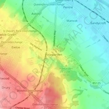
Name: Hawarden topographic map, elevation, terrain.

Location: Hawarden, Flintshire, Wales, CH5 3DQ, United Kingdom (53.16478 -3.04666 53.20478 -3.00666)

Average elevation: 57 m

Minimum elevation: 3 m

Maximum elevation: 140 m

Other topographic maps

Click on a map to view its topography, its elevation and its terrain.

Nannerch

United Kingdom > Wales > Flintshire > Nannerch

Average elevation: 232 m

Ewloe Castle

United Kingdom > Wales > Flintshire > Ewloe

Average elevation: 74 m

Penyffordd

United Kingdom > Wales > Flintshire

Average elevation: 101 m

Bagilt Reservior

United Kingdom > Wales > Flintshire > Bagillt

Average elevation: 32 m

Wepre Park

United Kingdom > Wales > Flintshire > Connah's Quay

Average elevation: 46 m

Saltney

United Kingdom > Wales > Flintshire

Average elevation: 9 m

Point of Ayr

United Kingdom > Wales > Flintshire > Talacre

Average elevation: 2 m

Gear up for your next adventure:

⛺Bushcraft Tarp - Versatile emergency shelter or gear protection
🔥Emergency Fire Starter - Reliable ignition source for all weather conditions
🧥Waterproof Pants - Keep dry during rainy hiking conditions
⛺Lightweight Backpacking Tent - Compact tent for efficient hiking trips
🥽Outdoor Goggles - Protective eyewear for outdoor activities

As an Amazon Associate, this site earns from qualifying purchases at no extra cost to you.