Geolocate

Calcott topographic map

Click on the map to display elevation.

About this map

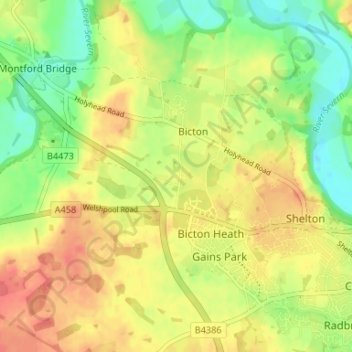
Name: Calcott topographic map, elevation, terrain.

Location: Calcott, Bicton, Shropshire, England, SY3 8EZ, United Kingdom (52.70011 -2.83664 52.74011 -2.79664)

Average elevation: 77 m

Minimum elevation: 48 m

Maximum elevation: 103 m

Other topographic maps

Click on a map to view its topography, its elevation and its terrain.

Bicton

United Kingdom > England > Shropshire > Bicton

Average elevation: 76 m

Gear up for your next adventure:

🥾Waterproof Hiking Boots - Boots keeping your feet dry in wet conditions
🛶Kayak Accessories - Essential gear for safe and fun kayaking adventures
🧴Bear Spray Holster - Quick-access carry for essential Canadian wilderness safety
🧰Survival Kit - Essential gear for emergencies in the wilderness
🧭GPS Outdoor Watch - Smart watch for navigation and fitness tracking in nature

As an Amazon Associate, this site earns from qualifying purchases at no extra cost to you.