Geolocate

Polomolok topographic map

Click on the map to display elevation.

About this map

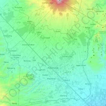
Name: Polomolok topographic map, elevation, terrain.

Location: Polomolok, South Cotabato, Soccsksargen, 9504, Philippines (6.14149 124.97320 6.36004 125.18962)

Average elevation: 485 m

Minimum elevation: 51 m

Maximum elevation: 2,253 m

Other topographic maps

Click on a map to view its topography, its elevation and its terrain.

Bukay Pait

Philippines > South Cotabato

Average elevation: 39 m

Tampakan

Philippines > South Cotabato

Average elevation: 142 m

San Isidro

Philippines > South Cotabato > San Isidro

Average elevation: 213 m

Desawo

Philippines > South Cotabato

Average elevation: 680 m

Gear up for your next adventure:

🥾Waterproof Hiking Boots - Boots keeping your feet dry in wet conditions
❄️Traction Ice Cleats - Slip-on spikes for icy trails and winter hiking
🧥Ultralight Puffy Jacket - Maximum warmth that packs down to the size of an orange
🛶Waterproof Dry Bags - Keep electronics and clothes dry during river crossings
🦶Hiking Shoe Insoles - Added support for high arches and long days on feet

As an Amazon Associate, this site earns from qualifying purchases at no extra cost to you.