Geolocate

Desawo topographic map

Click on the map to display elevation.

About this map

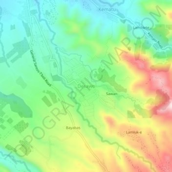
Name: Desawo topographic map, elevation, terrain.

Location: Desawo, South Cotabato, Soccsksargen, Philippines (6.17169 124.81904 6.21169 124.85904)

Average elevation: 680 m

Minimum elevation: 515 m

Maximum elevation: 966 m

Other topographic maps

Click on a map to view its topography, its elevation and its terrain.

Koronadal

Philippines > South Cotabato

Average elevation: 164 m

Polomolok

Philippines > South Cotabato

Average elevation: 485 m

Gear up for your next adventure:

🔋Lithium AA Batteries - Long-lasting power that performs in extreme cold
🪑Ultralight Camping Stool - Compact seating for rest stops during long hikes
🧦Hiking Socks - Moisture-wicking and comfortable socks for long hikes
🥫Freeze-Dried Meals - Lightweight, high-calorie nutrition for multi-day treks
🥾Trail Hiking Boots - Supportive boots for rough trails

As an Amazon Associate, this site earns from qualifying purchases at no extra cost to you.