Geolocate

Bonbon topographic map

Click on the map to display elevation.

About this map

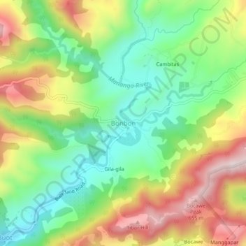
Name: Bonbon topographic map, elevation, terrain.

Location: Bonbon, Cebu City, Central Visayas, Philippines (10.34660 123.80771 10.38660 123.84771)

Average elevation: 374 m

Minimum elevation: 153 m

Maximum elevation: 683 m

Other topographic maps

Click on a map to view its topography, its elevation and its terrain.

Butuanon River

Philippines > Cebu City

Average elevation: 44 m

Fort San Pedro

Philippines > Cebu City

Average elevation: 3 m

San Roque

Philippines > Cebu City

Average elevation: 4 m

Hippodromo Park

Philippines > Cebu City

Average elevation: 13 m

Pari-an

Philippines > Cebu City

Average elevation: 8 m

TIEZA Pond

Philippines > Cebu City > Malubog

Average elevation: 471 m

Guadalupe River

Philippines > Cebu City

Average elevation: 220 m

Butuanon River

Philippines > Cebu City

Average elevation: 105 m

Kotkot River

Philippines > Cebu City

Average elevation: 316 m

SM Tower

Philippines > Cebu City

Average elevation: 3 m

Butuanon River

Philippines > Cebu City

Average elevation: 85 m

Butuanon River

Philippines > Cebu City

Average elevation: 41 m

CBP Central Park

Philippines > Cebu City

Average elevation: 19 m

Butuanon River

Philippines > Cebu City

Average elevation: 230 m

Sambag I

Philippines > Cebu City

Average elevation: 14 m

Mananga River

Philippines > Cebu City > Buot

Average elevation: 351 m

Buhisan Dam

Philippines > Cebu City > To-ong > Puti

Average elevation: 221 m

Gear up for your next adventure:

💧Collapsible Water Bottle - Space-saving water bottle for outdoor activities
🧢Sun Hat - Wide-brim hat for sun protection
👖Convertible Hiking Pants - Zip-off legs to adapt to changing weather conditions
Camping Tent - Weather-resistant tents suitable for 2 to 6 people
🧦Outdoor Socks - Durable socks designed for hiking and outdoor sports

As an Amazon Associate, this site earns from qualifying purchases at no extra cost to you.