
Make a donation
Gear up for your next adventure:
As an Amazon Associate, this site earns from qualifying purchases at no extra cost to you.
Vloesberg topographic map
Click on the map to display elevation.
Make a donation
Gear up for your next adventure:
As an Amazon Associate, this site earns from qualifying purchases at no extra cost to you.
Vloesberg
Vloesberg ligt in het Pays des Collines op een hoogte van 44 meter (kerk). Ten noorden van Vloesberg vindt men de bossen van het Pays des Collines: het Livierenbos, het Pottelbergbos en het Tournibois. De hoogte loopt hier op tot 145 meter. Een belangrijke waterloop is de Ruisseau d'Ancre.
Make a donation
Gear up for your next adventure:
As an Amazon Associate, this site earns from qualifying purchases at no extra cost to you.
About this map
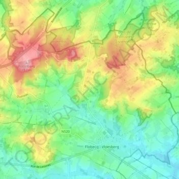
Name: Vloesberg topographic map, elevation, terrain.
Location: Vloesberg, Aat, Henegouwen, Wallonië, 7880, België (50.72931 3.68581 50.78187 3.77714)
Average elevation: 77 m
Minimum elevation: 24 m
Maximum elevation: 161 m
Make a donation
Gear up for your next adventure:
As an Amazon Associate, this site earns from qualifying purchases at no extra cost to you.
Other topographic maps
Click on a map to view its topography, its elevation and its terrain.