
Make a donation
Gear up for your next adventure:
As an Amazon Associate, this site earns from qualifying purchases at no extra cost to you.
Vloesberg topographic map
Click on the map to display elevation.
Make a donation
Gear up for your next adventure:
As an Amazon Associate, this site earns from qualifying purchases at no extra cost to you.
About this map
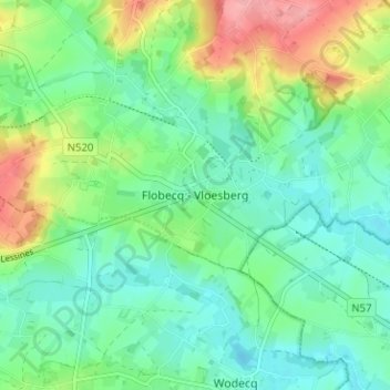
Name: Vloesberg topographic map, elevation, terrain.
Location: Vloesberg, Aat, Henegouwen, Wallonië, 7880, België (50.71717 3.71787 50.75717 3.75787)
Average elevation: 53 m
Minimum elevation: 23 m
Maximum elevation: 120 m
Make a donation
Gear up for your next adventure:
As an Amazon Associate, this site earns from qualifying purchases at no extra cost to you.
Other topographic maps
Click on a map to view its topography, its elevation and its terrain.
Vloesberg
België > Henegouwen > Aat > Vloesberg
Vloesberg ligt in het Pays des Collines op een hoogte van 44 meter (kerk). Ten noorden van Vloesberg vindt men de bossen van het Pays des Collines: het Livierenbos, het Pottelbergbos en het Tournibois. De hoogte loopt hier op tot 145 meter. Een belangrijke waterloop is de Ruisseau d'Ancre.
Average elevation: 77 m