
Make a donation
Gear up for your next adventure:
As an Amazon Associate, this site earns from qualifying purchases at no extra cost to you.
Abuan River topographic map
Click on the map to display elevation.
Make a donation
Gear up for your next adventure:
As an Amazon Associate, this site earns from qualifying purchases at no extra cost to you.
About this map
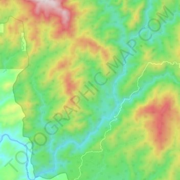
Name: Abuan River topographic map, elevation, terrain.
Location: Abuan River, Isabela, Cagayan Valley, Philippines (17.07623 122.09236 17.18074 122.19176)
Average elevation: 437 m
Minimum elevation: 89 m
Maximum elevation: 1,061 m
Make a donation
Gear up for your next adventure:
As an Amazon Associate, this site earns from qualifying purchases at no extra cost to you.
Other topographic maps
Click on a map to view its topography, its elevation and its terrain.
Make a donation
Gear up for your next adventure:
As an Amazon Associate, this site earns from qualifying purchases at no extra cost to you.
Make a donation
Gear up for your next adventure:
As an Amazon Associate, this site earns from qualifying purchases at no extra cost to you.
Make a donation
Gear up for your next adventure:
As an Amazon Associate, this site earns from qualifying purchases at no extra cost to you.
Roxas
The landscape of Roxas is relatively compose of flatlands with minimal rise at certain point with base mountain elevations on the eastern part, on the parts of Sinamar, Simimbaan and San Placido. It is approximately 90% of the land area comprising the town can be described as low-lying hills with rolling…
Average elevation: 59 m
Make a donation
Gear up for your next adventure:
As an Amazon Associate, this site earns from qualifying purchases at no extra cost to you.