Geolocate

Cordon topographic map

Click on the map to display elevation.

About this map

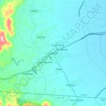
Name: Cordon topographic map, elevation, terrain.

Location: Cordon, Isabela, Cagayan Valley, 3312, Philippines (16.63400 121.42624 16.71400 121.50624)

Average elevation: 130 m

Minimum elevation: 86 m

Maximum elevation: 444 m

Other topographic maps

Click on a map to view its topography, its elevation and its terrain.

Abuan River

Philippines > Isabela

Average elevation: 437 m

Divilacan River

Philippines > Isabela > Divilacan

Average elevation: 182 m

Magat Dam

Philippines > Isabela

Average elevation: 176 m

Gear up for your next adventure:

🧦Crew Hiking Socks - Comfortable socks for long-distance hikes
🚑Survival Whistle - Signal for help across long distances in mountains
🧥Softshell Hiking Jacket - The perfect balance of wind protection and breathability
🚲Bike Repair Kit - Essential tools for on-trail mechanical issues
🥾Lightweight Hiking Boots - Boots for comfort and mobility on long hikes

As an Amazon Associate, this site earns from qualifying purchases at no extra cost to you.