Geolocate

Niceville topographic map

Click on the map to display elevation.

About this map

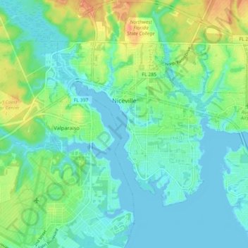
Name: Niceville topographic map, elevation, terrain.

Location: Niceville, Okaloosa County, Florida, United States (30.48439 -86.50630 30.53507 -86.41805)

Average elevation: 12 m

Minimum elevation: -3 m

Maximum elevation: 41 m

Other topographic maps

Click on a map to view its topography, its elevation and its terrain.

Holt

United States > Florida > Okaloosa County

Average elevation: 53 m

Deerland

United States > Florida > Okaloosa County

Average elevation: 63 m

Gear up for your next adventure:

🧼Biodegradable Camp Soap - Environmentally friendly cleaning for gear and body
🧭GPS Handheld Device - Reliable GPS navigation for outdoor adventures
🏕️Camping Hammock - Integrated protection for sleeping between trees
💧Collapsible Water Bottle - Space-saving water bottle for outdoor activities
🔭Compact Monocular - One-handed bird watching and trail spotting

As an Amazon Associate, this site earns from qualifying purchases at no extra cost to you.