Geolocate

Struthers topographic map

Click on the map to display elevation.

About this map

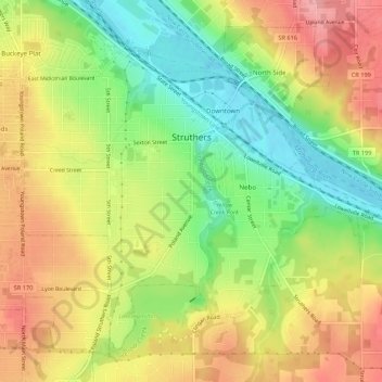
Name: Struthers topographic map, elevation, terrain.

Location: Struthers, Mahoning County, Ohio, 44471, United States (41.03081 -80.61590 41.06625 -80.56166)

Average elevation: 302 m

Minimum elevation: 248 m

Maximum elevation: 353 m

Other topographic maps

Click on a map to view its topography, its elevation and its terrain.

Austintown

United States > Ohio > Mahoning County

Average elevation: 318 m

Stony Ridge

United States > Ohio > Mahoning County > Austintown

Average elevation: 310 m

Uptown

United States > Ohio > Mahoning County > Youngstown

Average elevation: 314 m

Fosterville

United States > Ohio > Mahoning County > Youngstown

Average elevation: 313 m

Austintown

United States > Ohio > Mahoning County

Average elevation: 318 m

North Jackson

United States > Ohio > Mahoning County

Average elevation: 311 m

North Lima

United States > Ohio > Mahoning County

Average elevation: 335 m

Lake Milton

United States > Ohio > Mahoning County

Average elevation: 299 m

Gear up for your next adventure:

💡Solar Camping Lamp - Eco-friendly lighting for campsites
🔋Solar Power Bank - Keep your GPS and devices charged during long outdoor trips
🎒Fully Waterproof Backpack - Total protection for photography gear and electronics
💧Hydration Bladder - Hands-free hydration solution for long treks
🎒Hiking Daypack - Lightweight and durable backpacks for day trips and excursions

As an Amazon Associate, this site earns from qualifying purchases at no extra cost to you.