
Make a donation
Gear up for your next adventure:
As an Amazon Associate, this site earns from qualifying purchases at no extra cost to you.
Greeley Hill topographic map
Click on the map to display elevation.
Make a donation
Gear up for your next adventure:
As an Amazon Associate, this site earns from qualifying purchases at no extra cost to you.
Greeley Hill
Greeley Hill is a census-designated place in Mariposa County, California, United States. Greeley Hill sits at an elevation of 3,153 feet (961 m) in the foothills of the Sierra Nevada. The 2020 United States census reported Greeley Hill's population as 927.
Make a donation
Gear up for your next adventure:
As an Amazon Associate, this site earns from qualifying purchases at no extra cost to you.
About this map
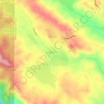
Name: Greeley Hill topographic map, elevation, terrain.
Location: Greeley Hill, Mariposa County, California, United States (37.72489 -120.14983 37.76489 -120.10983)
Average elevation: 987 m
Minimum elevation: 842 m
Maximum elevation: 1,095 m
Make a donation
Gear up for your next adventure:
As an Amazon Associate, this site earns from qualifying purchases at no extra cost to you.
Other topographic maps
Click on a map to view its topography, its elevation and its terrain.
Yosemite Valley
United States > California > Mariposa County > Yosemite Village
Average elevation: 2,016 m
Echo Valley
United States > California > Mariposa County
Echo Valley is a valley in Yosemite National Park, at an elevation of 7,021 feet (2,140 m). It is located along Echo Creek, about 3 miles (5 km) west of Merced Lake, at 37°44′38″N 119°26′03″W / 37.7438°N 119.4343°W / 37.7438; -119.4343. It is bounded on the south by the Merced River.
Average elevation: 2,333 m
Make a donation
Gear up for your next adventure:
As an Amazon Associate, this site earns from qualifying purchases at no extra cost to you.
Yosemite Valley
United States > California > Mariposa County > Yosemite Village
Average elevation: 2,012 m
Yosemite Valley
United States > California > Mariposa County > Yosemite Village
Average elevation: 2,016 m