
Yosemite Valley topographic map
Click on the map to display elevation.
About this map
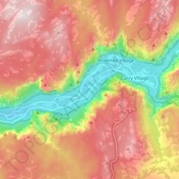
Name: Yosemite Valley topographic map, elevation, terrain.
Average elevation: 2,012 m
Minimum elevation: 1,182 m
Maximum elevation: 2,736 m
Other topographic maps
Click on a map to view its topography, its elevation and its terrain.
Middle Cascades
United States > California > Mariposa County > Yosemite Village
Average elevation: 1,783 m
Middle Cascades
United States > California > Mariposa County > Yosemite Village
Average elevation: 1,783 m