
Parkgate topographic map
Click on the map to display elevation.
About this map
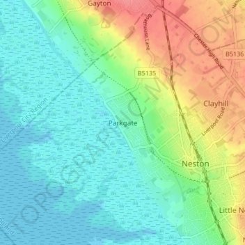
Name: Parkgate topographic map, elevation, terrain.
Average elevation: 22 m
Minimum elevation: -1 m
Maximum elevation: 68 m
Other topographic maps
Click on a map to view its topography, its elevation and its terrain.
Wirral Country Park
United Kingdom > England > Cheshire West and Chester > Neston > Windle Hill
Average elevation: 49 m
Ness Wood
United Kingdom > England > Cheshire West and Chester > Neston > Ness
Average elevation: 53 m