Geolocate

Naga River topographic map

Click on the map to display elevation.

About this map

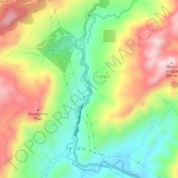
Name: Naga River topographic map, elevation, terrain.

Location: Naga River, Uling, Cebu, Central Visayas, 6037, Philippines (10.25009 123.70886 10.28892 123.72546)

Average elevation: 255 m

Minimum elevation: 49 m

Maximum elevation: 515 m

Other topographic maps

Click on a map to view its topography, its elevation and its terrain.

Uling

Philippines > Cebu > Uling

Average elevation: 314 m

Gear up for your next adventure:

🧥Ultralight Puffy Jacket - Maximum warmth that packs down to the size of an orange
🕶️Polarized Sunglasses - Reduces glare from snow and water at high elevations
🥘Camping Cookware Set - Compact nesting pots and pans for trail cooking
🔦LED Headtorch - Bright and durable light for night activities
🧢Hiking Sun Hat - Wide-brimmed protection for exposed mountain ridges

As an Amazon Associate, this site earns from qualifying purchases at no extra cost to you.