Geolocate

Machen topographic map

Click on the map to display elevation.

About this map
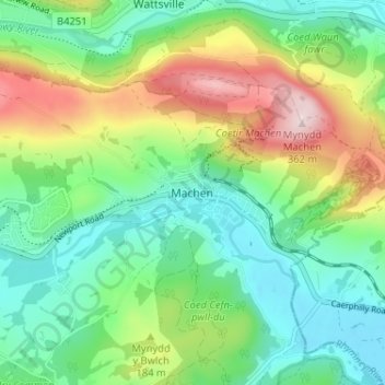
Name: Machen topographic map, elevation, terrain.

Location: Machen, Caerphilly County Borough, Wales, CF83 8PQ, United Kingdom (51.57632 -3.16062 51.61632 -3.12062)

Average elevation: 143 m

Minimum elevation: 35 m

Maximum elevation: 362 m

Other topographic maps

Click on a map to view its topography, its elevation and its terrain.

Van

United Kingdom > Wales > Caerphilly County Borough

Average elevation: 96 m

Gear up for your next adventure:

💡LED Camping Lantern - Illuminate your campsite with long-lasting lanterns
🦌Outdoor Trail Camera - Monitor wildlife activity near your favorite spots
🔦UV Flashlight - Detect minerals or specific insects in the dark
🧭GPS Handheld Device - Reliable GPS navigation for outdoor adventures
⛺Camping Essentials - All-in-one gear for a comfortable camping trip

As an Amazon Associate, this site earns from qualifying purchases at no extra cost to you.