
Canton topographic map
Click on the map to display elevation.
About this map
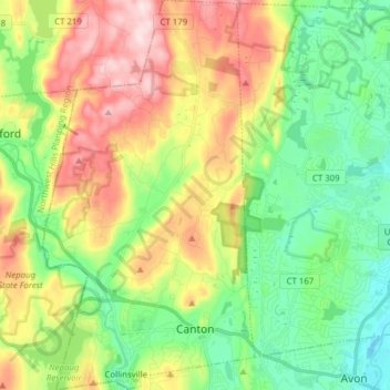
Name: Canton topographic map, elevation, terrain.
Location: Canton, Capitol Planning Region, Connecticut, United States (41.80643 -72.95433 41.92169 -72.87014)
Average elevation: 164 m
Minimum elevation: 38 m
Maximum elevation: 368 m
Other topographic maps
Click on a map to view its topography, its elevation and its terrain.
West Suffield
United States > Connecticut > Capitol Planning Region > Suffield
Average elevation: 59 m
Plantsville
United States > Connecticut > Capitol Planning Region > Southington
Average elevation: 57 m
Four Corners
United States > Connecticut > Capitol Planning Region > Terramuggus
Average elevation: 143 m
Burnside
United States > Connecticut > Capitol Planning Region > East Hartford
Average elevation: 24 m
Willington Hill
United States > Connecticut > Capitol Planning Region > Willington
Average elevation: 197 m
Griswoldville
United States > Connecticut > Capitol Planning Region > Wethersfield
Average elevation: 34 m
Chaffeeville
United States > Connecticut > Capitol Planning Region > Mansfield
Average elevation: 133 m
West District
United States > Connecticut > Capitol Planning Region > Farmington
Average elevation: 92 m
Talcott Mountain
United States > Connecticut > Capitol Planning Region > Bloomfield
Average elevation: 152 m
South Wethersfield
United States > Connecticut > Capitol Planning Region > Wethersfield > Griswoldville
Average elevation: 22 m
North Coventry
United States > Connecticut > Capitol Planning Region > Coventry
Average elevation: 195 m
North Thompsonville
United States > Connecticut > Capitol Planning Region > Enfield
Average elevation: 31 m
Buckingham
United States > Connecticut > Capitol Planning Region > Glastonbury
Average elevation: 131 m
Stafford Springs
United States > Connecticut > Capitol Planning Region > Stafford
Average elevation: 200 m
Bishop's Corner
United States > Connecticut > Capitol Planning Region > West Hartford
Average elevation: 47 m
Talcott Mountain
United States > Connecticut > Capitol Planning Region > Bloomfield
Average elevation: 152 m
Johnson Hill
United States > Connecticut > Capitol Planning Region > West Hartford
Average elevation: 34 m
Holcomb Farm
United States > Connecticut > Capitol Planning Region > Granby > West Granby
Average elevation: 116 m
Barbara Drive
United States > Connecticut > Capitol Planning Region > Windsor Locks
Average elevation: 39 m
Spoonville
United States > Connecticut > Capitol Planning Region > East Granby
Average elevation: 62 m
Cottage Grove
United States > Connecticut > Capitol Planning Region > Bloomfield
Average elevation: 31 m