Geolocate

Glenbrook topographic map

Click on the map to display elevation.

About this map

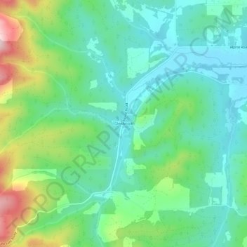
Name: Glenbrook topographic map, elevation, terrain.

Location: Glenbrook, Benton County, Oregon, United States (44.29373 -123.42649 44.33373 -123.38649)

Average elevation: 180 m

Minimum elevation: 91 m

Maximum elevation: 406 m

Other topographic maps

Click on a map to view its topography, its elevation and its terrain.

Corvallis

United States > Oregon > Benton County

Average elevation: 81 m

Corvallis

United States > Oregon > Benton County

Corvallis is at an elevation of 235 feet (72 m) above sea level. Situated midway in the Willamette Valley, in terms of driving distances, Corvallis is about 46 miles (74 km) east of Newport and the Oregon Coast, 85 miles (137 km) south of Portland, 30 miles (48 km) south of the state capital, Salem, 10 miles…

Average elevation: 81 m

Adair Village

United States > Oregon > Benton County

Average elevation: 100 m

Philomath

United States > Oregon > Benton County

Average elevation: 104 m

Corvallis

United States > Oregon > Benton County

Average elevation: 81 m

Gear up for your next adventure:

🛰️Satellite Messenger - Emergency communication for areas with no cell service
🧦Crew Hiking Socks - Comfortable socks for long-distance hikes
🧭GPS Outdoor Watch - Smart watch for navigation and fitness tracking in nature
🧢Hiking Sun Hat - Wide-brimmed protection for exposed mountain ridges
🥾Trekking Poles - Adjustable trekking poles to reduce knee stress and improve stability

As an Amazon Associate, this site earns from qualifying purchases at no extra cost to you.