Geolocate

Philomath topographic map

Click on the map to display elevation.

About this map

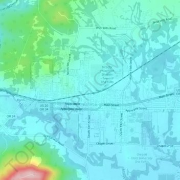
Name: Philomath topographic map, elevation, terrain.

Location: Philomath, Benton County, Oregon, 97370, United States (44.53191 -123.38417 44.55393 -123.33447)

Average elevation: 104 m

Minimum elevation: 72 m

Maximum elevation: 292 m

Other topographic maps

Click on a map to view its topography, its elevation and its terrain.

Alsea

United States > Oregon > Benton County

Average elevation: 154 m

Coast Range

United States > Oregon > Benton County

Average elevation: 824 m

Glenbrook

United States > Oregon > Benton County

Average elevation: 180 m

Forest Peak

United States > Oregon > Benton County

Average elevation: 385 m

Kings Valley

United States > Oregon > Benton County

Average elevation: 125 m

Gear up for your next adventure:

🔭Outdoor Binoculars - Lightweight binoculars for birdwatching and hiking
🔦UV Flashlight - Detect minerals or specific insects in the dark
🧼Biodegradable Camp Soap - Environmentally friendly cleaning for gear and body
🧭GPS Handheld Device - Reliable GPS navigation for outdoor adventures
Lightweight Camping Tent - Portable shelter optimized for Canadian backcountry camping

As an Amazon Associate, this site earns from qualifying purchases at no extra cost to you.