
Isleworth topographic map
Click on the map to display elevation.
Isleworth
If deemed to still include Osterley, elevations range from 27 m (89 ft) in the northwest to 4.9 m (16 ft) by the Thames OD. The boundaries are longstanding, subject to twentieth-century western and southern circonscriptions: Isleworth is east of the town of Hounslow which has more retail and offices, in the borough of that name; west of the River Thames; north of its tributary and the northernmost confluence of the Crane; and south of the crest by the M4 motorway separating the Brent and Crane catchments. Half of the River Crane flows into the Thames south of the Ait, and its newest distributary the Duke of Northumberland's River flows toward the Ait's midpoint.
About this map
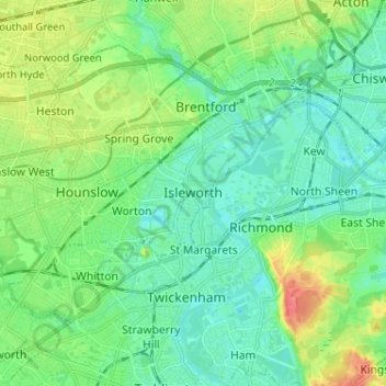
Name: Isleworth topographic map, elevation, terrain.
Location: Isleworth, Greater London, England, TW7 7AL, United Kingdom (51.42852 -0.36597 51.50852 -0.28597)
Average elevation: 19 m
Minimum elevation: 2 m
Maximum elevation: 63 m
Other topographic maps
Click on a map to view its topography, its elevation and its terrain.
London Borough of Richmond upon Thames
United Kingdom > England > Greater London
Average elevation: 18 m
Norwood Grove
United Kingdom > England > Greater London
After Anderson died, ownership passed to the Nettlefold family and subsequently to Frederick Nettlefold the brother of Joseph Nettlefold and a member of the family that founded the Nettlefolds Ltd. engineering firm which later became GKN. Nettlefold is commemorated, as a result of his charitable works, by a…
Average elevation: 58 m
Pymmes Brook
United Kingdom > England > Greater London
Prior to the Anglian glaciation, a "proto-Mole-Wey" river was flowing northwards from the Weald and North Downs, through the "Finchley depression" and Palmers Green, to join the proto-Thames somewhere around Hoddesdon, at what is today an altitude of around 60 metres. It was this river which, during the course…
Average elevation: 41 m